Mt. Nebo banded calcite
Uploaded By Scott (webmaster) Uploaded on Monday, August 17, 2009 at 04:31:23 PM Viewed 5764 times |

| This website or the contributor can't guarantee the information here to be accurate or to be up-to-date, although that is the intention for the data. Illegal activity or property damage is not the responsibility of this website, but each visitor is encouraged to review the Rockhound Code of Ethics. Each website visitor is advised also to consider reference sources listed and outside sources in their research before visiting the location. |
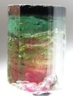
Details: The Mt. Nebo deposit consists of reddish-orange and cream-colored banded calcite according to the Utah Geological Survey website. It says: "Geologic information: Although the rocks at this site are commonly called onyx (on-iks) or onyx marble, they are not true onyx. True onyx is parallel-banded chalcedony, a cryptocrystalline (microscopic crystals) variety of quartz. The Mt. Nebo deposit consists of reddish-orange and cream-colored banded calcite. Calcite is composed of calcium carbonate (CaCO3). Banded calcite is formed when calcium carbonate precipitates (separates out) from a solution of dissolved calcium carbonate and ground water. The calcium carbonate is deposited within a large opening or fissure in the mother rock and parallel bands are created as additional calcium carbonate precipitates. The changes in the color banding are probably caused by slight changes in the chemical composition of ground water during precipitation. The Mt. Nebo banded calcite can be polished and used for decorative purposes, such as bookends."
Directions: Directions can be found at the Utah Geological Survey website. It says: "How to get there: Travel about 5 miles east of Nephi on State Highway 132 to the Mt. Nebo Scenic Loop intersection. Turn north (left) onto the Mt. Nebo road and travel approximately 3 miles until you reach the turnoff to the Mt. Nebo Scenic Loop. Stop and park in the open space on the west (left) side of the main road. Where to collect: Walk about 0.2 miles up the Mt. Nebo Scenic Loop road until you see faint tracks on the northwest (left side of road). Follow the trail uphill about 0.5 miles to the collecting site, a red and white knoll west (left) of the trail. Go around to the other side of this knoll for the best collecting. Numerous large and small rock samples litter the ground on the west side of the knoll. To obtain a sample from the outcrop you will need to remove it with a rock hammer or a hammer and chisel. Please remember to wear your safety glasses."
 Now On eBay(View More) Now On eBay(View More) | ||||||||||||||||||||
|
|
| ||||||||||||||||||


GPS Coordinates (lat,long): ( 39°46'4.22"N, 111°42'33.96"W)
or (39.767838, -111.709433)
Google Map: (The GPS marker is supposed to be exact.)
Tags: mt. nebo banded calcite onyx nephi utah juab county


No comments have been left yet