Old Ponca Lead Mine Tailing Piles
Uploaded By Scott (webmaster) Uploaded on Thursday, April 16, 2009 at 10:38:54 AM Viewed 6767 times |

 DSCN9150.JPG |
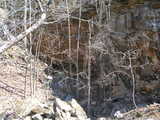 DSCN9151.JPG |
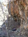 DSCN9158.JPG |
| This website or the contributor can't guarantee the information here to be accurate or to be up-to-date, although that is the intention for the data. Illegal activity or property damage is not the responsibility of this website, but each visitor is encouraged to review the Rockhound Code of Ethics. Each website visitor is advised also to consider reference sources listed and outside sources in their research before visiting the location. |
Details: From rockhoundinginar.com: "Good hand specimens of galena with minor sphalerite are found in the dumps". Some information on the history is found at this link: http://www.buffaloriverrealestate.com/Rockhounding.htm
Directions:
I still haven't found the good places by myself. I found a stray dog, old mining roads and dead deer carcasses. Here is what findingrocksinar.com says: "Several abandoned lead mines may be reached by Arkansas Highway 43 north out of Ponca. Approximately 2.5 mines from Ponca and near the crest of the hill a dirt trail to the west is passable for a short distance downhill to near the mines."
Update 3/20/2011: Found the place this time with some other people. There may be other tailing piles, but we visited a couple that included one with banded calcite and another near the mine entrance with galena in the dumps. One old mine road can be found just after a guardrail going north out of Ponca on 43. This mine road goes sort of downhill slightly and then uphill slighly after a few hundred yards. One tailing pile with banded calcite is before the road zags back the other direction down the hill. From the guardrail go straight down the hill and to the right and you'll find the mine entrance. Use a metal detector to find galena.
 Now On eBay(View More) Now On eBay(View More) | ||||||||||||||||||||
|
|
| ||||||||||||||||||


GPS Coordinates (lat,long): ( 36° 3'2.11"N, 93°21'27.21"W)
or (36.050586, -93.357558)
Google Map: (The GPS marker is intended to be approximate or best guess.)
Mindat Link: http://www.mindat.org/rloc.php?loc=Ponca%2C+Ponca-Boxley+District%2C+Newton+Co.%2C+Arkansas%2C+USA
Tags: galena, sphalerite, calcite, banded calcite, calcium, calcite cleaves, buffalo river wilderness area, ponca, arkansas, calcite cubes, dogtooth, tailing piles, dumps, newton county, highway 43, 43, metal detecting
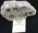 AnglesiteGal... |
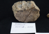 BarytePonca.png |
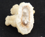 Calcite2Ponc... |
|